

A lake that forms in a volcanic caldera or crater is called a crater lake. Lakes may form in impact craters that are caused by meteorites or in craters made from the effects of man-made explosives. As the precipitation within the rim fills the created depression, the crater lake is formed. An equilibrium is reached between the amount of incoming and outgoing water as the water level rises in the depression. Water loss in crater lakes are often caused by (singly or together) evaporation, surface leakage or overflow, and subsurface seepage. The water in volcanic lakes (lakes that cover volcanic vents or fumarolic) is often acidic, saturated with volcanic gases, cloudy, and strong greenish in color; while lakes that cover dormant or extinct volcanoes feature fresh water. The clarity of these lakes’ water is exceptional because of the lack of in-flowing streams and sediment. The gallery below features some of the most striking and beautiful crater lakes in the world. Enjoy their beauty!
Vulcan Point within Crater Lake, Taal Volcano (Batangas, Philippines)

Located in the province of Batangas on the island of Luzon, Philippines, Taal Volcano is a complex volcano. The volcanic eruptions are concentrated on an island near the center of Lake Taal called Volcano Island. The lake partially fills a caldera, which was formed through powerful prehistoric eruptions that happened between 140,000 and 5,380 BP. The caldera is named Taal Caldera. A large rock called Vulcan Point, projected from the crater lake’s surface, is a remain of the old crater floor, which is now surrounded by a 2-km-wide lake called the Main Crater Lake. Vulcan Point is considered to be the world’s largest island within a lake on an island within a lake on an island (whew!). Here’s a (hopefully) more detailed description: the Vulcan Point is within Crater Lake that is on Taal Island within Lake Taal on the island of Luzon. The Taal Volcano and its lake is one of the most beautiful views in the Philippines. To see its whole beauty, visitors should head to Tagaytay Ridge for a panoramic view. The wonder of nature is about 50 km south of Metro Manila, the capital of the country.
Crater Lakes in the Albertine Rift (Africa)

The rift floor in Queen Elizabeth Park is full of crater lakes, which are all formed by volcanic explosions in the past. According to conservationists, if the protected areas haven’t been set aside in the Albertine Rift from the 1920s to the 60s, many of the wilderness areas wouldn’t have existed today. The Albertine Rift or the Western Rift is located at the edges of some of the highest mountains in Africa. The Virunga Mountains, Mitumba Mountains, and Ruwenzori Range surround the Western Rift. The rift features the Rift Valley Lakes, which are some of the deepest lakes in the world. Some of them are as deep as 1,470 meters (Lake Tanganyika). The area mostly lies in the boundaries of national parks such as Virunga National Park in the Democratic Republic of Congo, Rwenzori National Park and Queen Elizabeth National Park in Uganda, and Volcanoes National Park in Rwanda. The picturesque Lake Victoria is considered to be part of the rift valley system even though only half of it actually lies in it. All of the African Great Lakes were formed in the rift, and most of them lie within its rift valley.
Deriba Crater Lake, Jebel Marra (Darfur, Sudan)
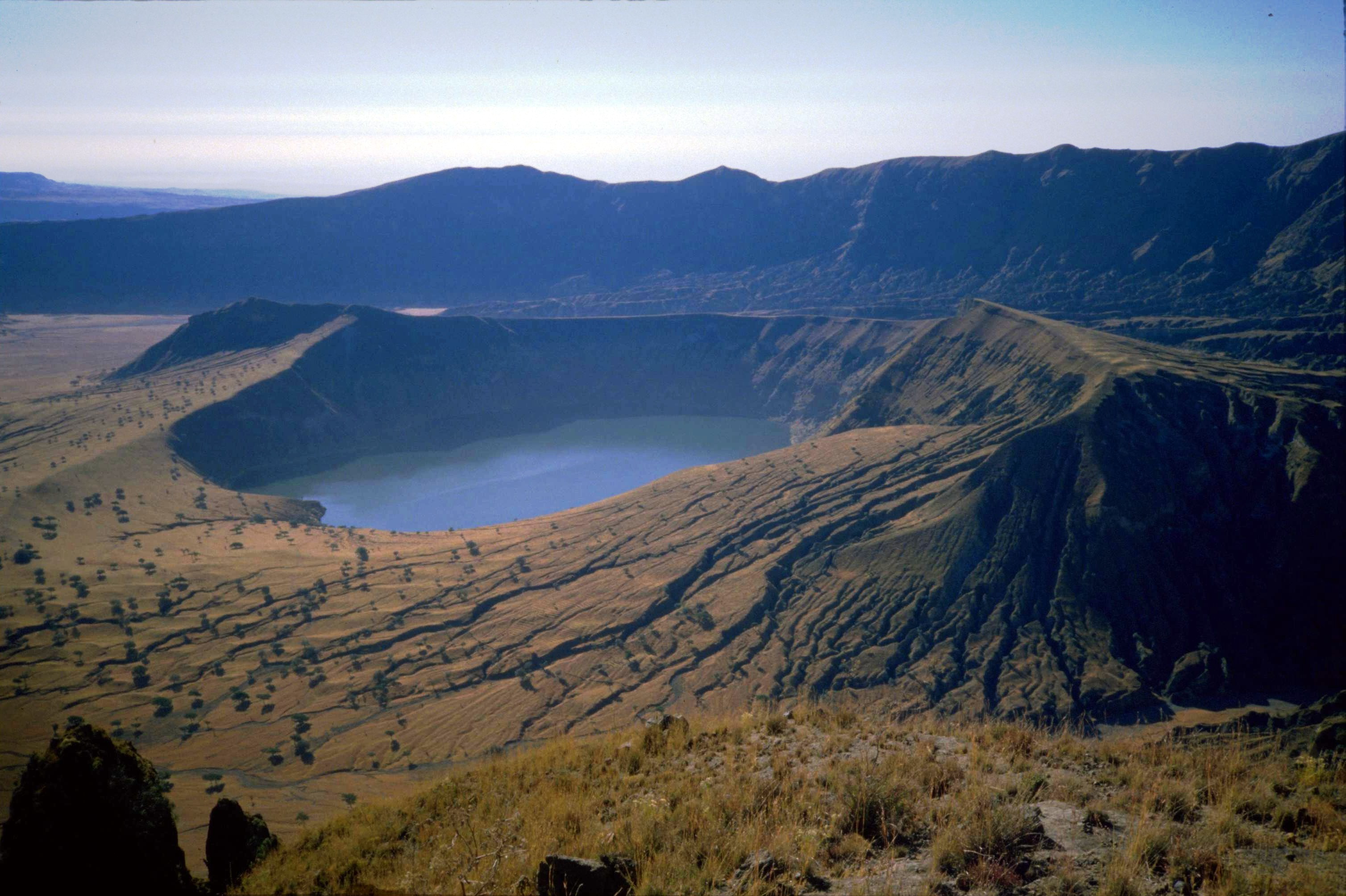
With an elevation of 3,042 m (9,980 ft), the Deriba Crater is the highest point of Jebel Marra. The crater is located in Darfur in western Sudan. The caldera is between 5 km and 8 km in diameter across the outer crater. A crater lake fills the inner crater. The Deriba Caldera came to existence because of the eruption of the Jebel Marra Volcano about 3,5000 years ago. The volcano is now dormant or extinct but hot springs and fumaroles (gas and steam vents) are still present. The caldera rim has become the highest point in Sudan after South Sudan became independent.
Crater Lake, Mount Pinatubo (Luzon, Philippines)

When Mount Pinatubo erupted on June 15, 1991, the Lake Pinatubo was formed. Classified as a summit crater lake, the Lake Pinatubo is the deepest lake in the Philippines with a depth of 800 m. It is located in the boundaries of Pampanga, Tarlac, and Zambales provinces in the Philippines, about 90 km northwest of its capital, Metro Manila.
Crater Lake, Licancabur (Chile and Bolivia)

On the southernmost part of Chile and Bolivia’s border, the highly symmetrical stratovolcano (composite volcano) Licancabur is found. The volcano, which is located just southwest of Laguna Verde, dominates the landscape of the Salar de Atacama area. Because the massive volcano is situated between the borders of Chile and Bolivia, ownership of the crater is divided between two countries. The volcano’s lower two-thirds of the northeastern slope, 5,400 m from the foot to 4,360 m, belongs to Bolivia; while the rest and the bigger part of the volcano, including its crater and summit, is under the management of the Chilean government. The volcano features a 400 m wide crater that contains a 70 m by 90 m crater lake called Licancabur Lake. The lake is one of the highest lakes in the world. Its temperature can drop to -30 °C, causing the lake to be covered with ice most of the year. But even with its extreme coldness, the lake is home to planktonic fauna.
Crater Lake, Mount Mazama (Oregon, USA)

The Crater Lake in Oregon is one the most known crater lakes in the world. The lake is the deepest in the USA with a depth of 594 m, and it is located in the caldera of Mount Mazama. The lake got its water solely from falling rain and snow. There is no inflow or outflow at the surface, making the crater lake one of the clearest in the world.
Crater Lake, Mount Katmai (Alaska, USA)

Mount Katmai, a large stratovolcano, is located within the bounds of Katmai National Park and Preserve on the Alaskan Peninsula in southern Alaska. The 6.3 miles in diameter volcano features a lake caldera in the center. The caldera, which has an area of about 3 by 2 miles, was formed by the 1912 Novarupta eruption. The rim of the caldera has a maximum elevation of 6,716 feet. The surface of the lake is elevated at about 4,220 feet, according to a 1975 measurements. The caldera floor is estimated to be at an elevation of 3,400 feet.
Viti Geothermal Crater Lake, Askja (Iceland)
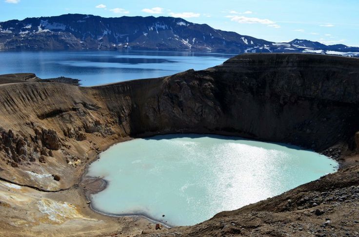
Askja is an Icelandic stratovolcano that is located in the remote part of the central highlands of Iceland. The name, which means box or caldera in Danish, is a reference to a complex of calderas within the surrounding Dyngjufjoll mountains. The volcano is situated in the rain-shadow, northeast of the Vatnajökull icecap. Askja only receives about 450 mm of rainfall every year, and the mountain is only accessible to climbers for a few months of the year. The volcano was the training ground for the Apollo program. The area was used to prepare astronauts for the lunar missions, and their main objective in Askja was to study geology. One of the many crater lakes in Askja is the Oskjuvatn. The large lake fills a small caldera that was formed during an eruption in 1875. The lake’s surface lies about 50 m below the level of the main crater floor and covers about 12 km². Because it was formed by an eruption, the lake’s water was originally warm, but today it stays frozen most of the year. The Oskjuvatn is Iceland’s second-deepest lake at 220 m deep. There is a smaller crater on the northeastern shore of Oskjuvatn that is about 150 meters in diameter. The crater has a geothermal lake that is rich in minerals and has a sulfurous, opaque blue water.
Crater Lake, Mount Ruapehu (New Zealand)

At the southern end of the Taupo Volcanic Zone in New Zealand, the Mount Ruapehu (or just Ruapehu), an active stratovolcano, is found. The stratovolcano is just 23 km northeast of Ohakune and 40 km southwest of the southern shore of Lake Taupo in the Tongariro National Park. The volcano New Zealand’s largest active volcano and named as the most active in the world. Ruapehu is the highest point in the North Island with its other three major peaks, which are Tahurangi (2,797 m), Te Heuheu (2,755 m), and Paretetaitonga (2,751 m). The stratovolcano has a deep and active crater between its peaks. The crater becomes a lake in between major eruptions.
Kerið Crater Lake (South Iceland)

On the popular tourist route known as the Golden Circle, visitors can find a volcanic crater lake named Kerid. The crater lake is located in the Grímsnes area in south Iceland. Kerid is just one of several crater lakes in Iceland’s Western Volcanic Zone. The other spectacular wonders include the famous Reykjanes Peninsula and the Langjökull Glacier, which were formed as the land moved over a localized hot spot. The Kerid is one of the most visually recognizable caldera that remained intact. Kerid is composed of red—instead of the usual black—rocks just like other volcanic rocks in the area. The Kerid caldera is about 55 m deep, 170 m, and 270 m across and is readily distinguishable because of it being approximately 3,000 years old (although the crater is only half the age of the most of the surrounding volcanic features). One wall of the caldera is sloped gently and is blanketed with deep moss while the rest of the crater’s wall is steep and has little to no vegetation. Kerid Crater Lake is actually shallow at around 7 to 14 meters (depending of the amount of rainfall and some other factors), but its water is opaque and has vivid aquamarine due to the minerals from the soil.
Heaven Lake, Baekdu Mountain (China and North Korea)

This crater lake is on the border separating China and North Korea. The Heaven Lake is located within a caldera on top of the Baekdu Mountain, a volcanic mountain that forms part of the mountain ranges Baekdudaegan and Changbai. The lake is partly located in Ryanggang Province, North Korea, at 42.006°N 128.057°E, and partly in the northeastern Chinese province of Jilin. The Heaven Lake is in a caldera that was formed by a major volcanic eruption in 969 CE. Its surface has an elevation of 2,189.1 m. The whole lake covers an area of 9.82 km² with a south-north length of 4.85 km and east-west length of 3.35 km. The lake has an average depth of 213 m and a maximum depth of 284 m. Heaven Lake is typically covered with ice from mid-October to mid-June.
Kelimutu Crater Lake (Flores Island, Indonesia)
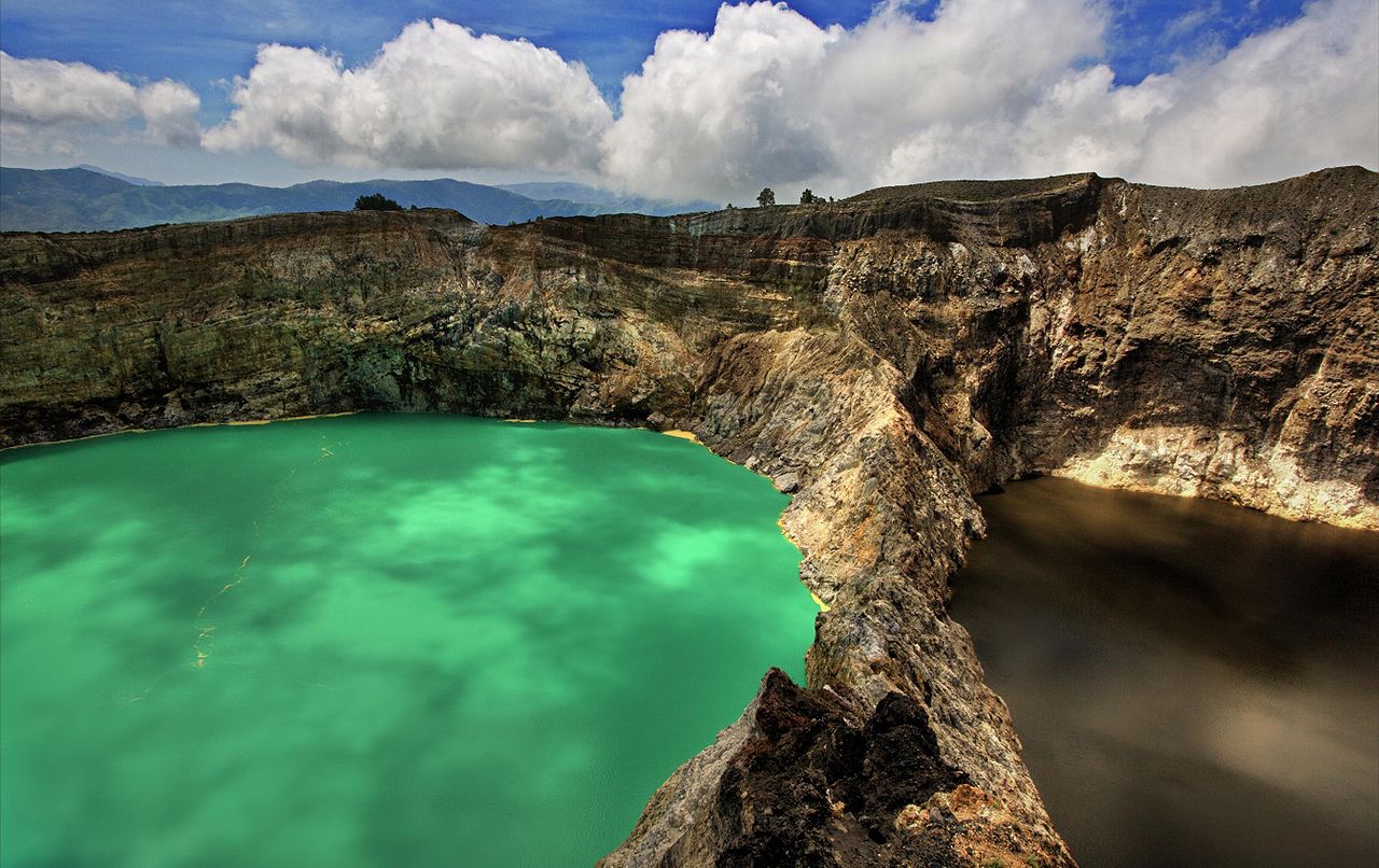
The Kelimutu Volcano in Indonesia features three summit crater lakes that strikingly vary in colors. On the westernmost part, the Tiwu Ata Mbupu (Lake of Old People) is usually blue. Tiwu Nuwa Muri Koo Fai (Lake of Young Men and Maidens) and Tiwu Ata Polo (Bewitched or Enchanted Lake) are the other two crater lakes. They are separated by a single and shared crater wall. The Tiwu Nuwa Muri Koo Fai usually sports a green water while the Tiwu Ata Polo has reddish water. Kelimutu’s varying colors are what most geologists are intrigued about the volcano.
Quilotoa Crater Lake (Ecuador)
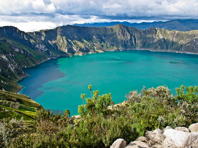
The most western volcano in the Ecuadorian Andes, Quilotoa is a water-filled caldera. The 3-km-wide caldera was created when the dacite volcano collapsed following the catastrophic VEI-6 eruption about 800 years ago. The eruption caused pyroclastic flows and lahars that reached the Pacific Ocean and even spread and airborne deposit of volcanic ash throughout the northern Andes. Over the years, the caldera has accumulated about 250 m of water to form the deep crater lake. The lake has a greenish color because of dissolved minerals. On the lake floor, fumaroles are found, and hot springs happen on the volcano’s eastern flank.
Yak Loum Crater Lake (Ratanakiri, Cambodia)
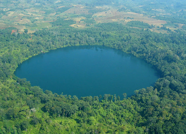
One of the most popular tourist destinations in Ratanakiri province of northeastern Cambodia is the Yak Loum. Yak Loum is a lake located just 3 miles away from the provincial capital, Banlung. The lake is located on a 4,000-year-old volcanic crater. Yak Loum has a depth of 48 m, and its water is exceptionally clear and clean. It is almost perfectly round and is about 0.45 mi in diameter. The lake is surrounded by large trees of a lush rain forest that is home to many exotic birds and parrots.
Crater Lake (Okama), Mt. Zao (Honshu, Japan)

Mount Zao is a complex volcano that consists of a cluster of stratovolcanoes. It’s the most active volcano in northern Honshu, and it is located on the border between Yamagata Prefecture and Miyagi Prefecture in Japan. Goshiki-dake is the central volcano of the group. The volcano features several lava dome and a tuff cone. A crater lake named Okama is also one of Goshiki-dake’s features. The Okama is also known as the Five-Color Pond because the lake changes color depending on the weather. Okama lies in a crater that was formed in a volcanic eruption in the 1720s. The lake is about 360 m in diameter and 60 m deep. The Okama is one of the most famous tourist attractions in the area.
For more interesting articles, click the links below.
Dare to Take on These Extreme Sports In The World’s Most Amazing Places
These are the 12 Most Stomach-Churning Ziplines around the World …This is Intense!
Here are Some of the Best-Kept Secret’s About California’s Coastline …Prepare to be Stunned!